
English| EUR
Suggested for you
More currencies
Choose a language
The Ngong Hills ridge stretches 14 kilometers from the first summit to the seventh, threading through grassland, forested slopes, and exposed ridgeline. Most hikers complete the traverse in four to six hours, though the cumulative elevation gain and uneven footing slow progress more than the distance suggests. This guide maps the route, breaks down each segment, and explains why the trail plays longer than the numbers promise.
Quick answer
The ngong hills hike distance measures 14 kilometers end-to-end along the main ridge trail, crossing all seven peaks with a cumulative elevation gain of approximately 1,100 meters. The route is not a loop—most hikers start at the main gate and finish at the opposite trailhead, requiring pre-arranged transport. Terrain shifts from wide dirt paths to narrow rocky scrambles, and exposed sections amplify sun and wind exposure.
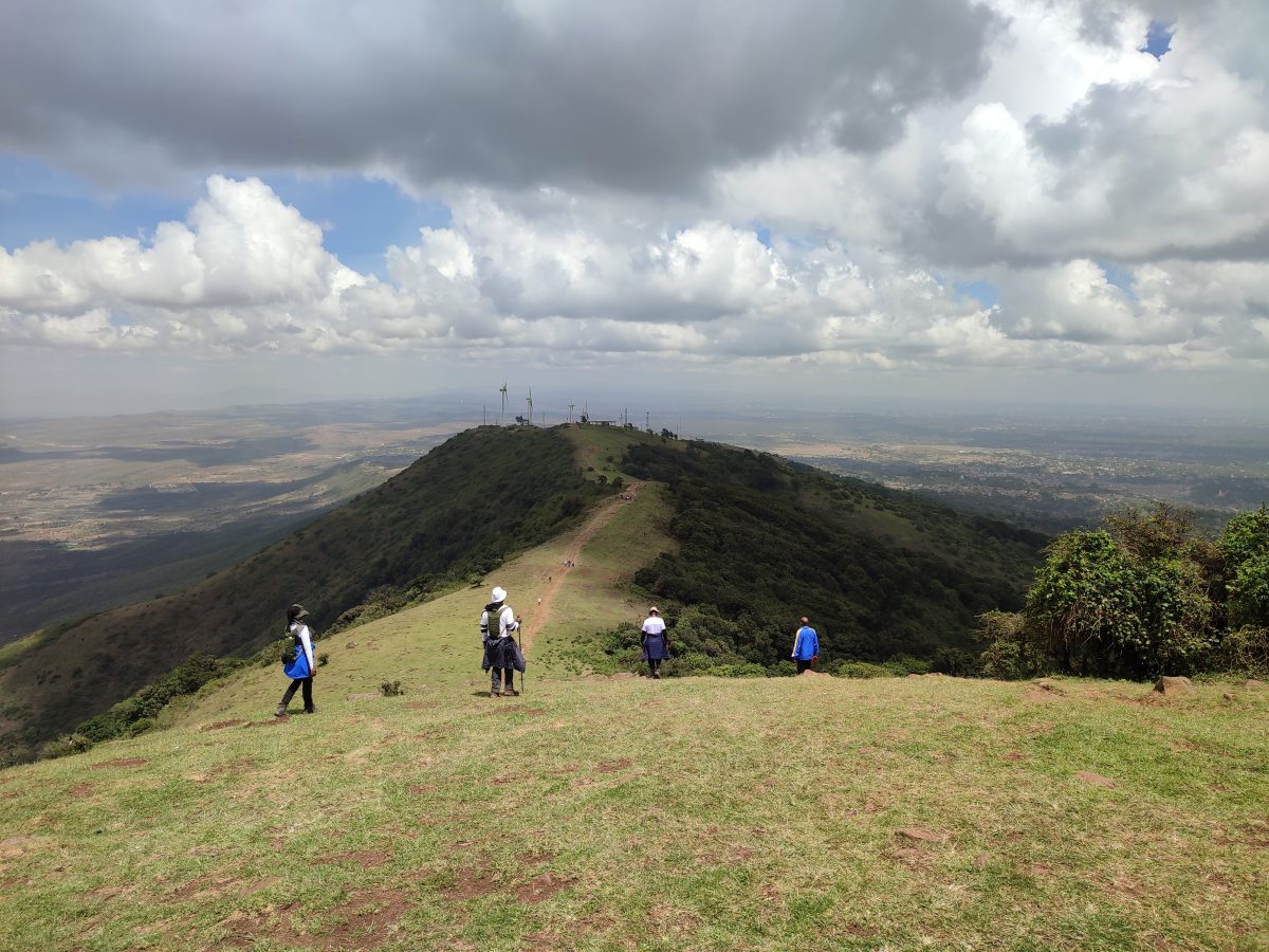
The Ngong Hills ridge runs 14 kilometers southwest of Nairobi, a green spine rising 2,460 meters above sea level at its highest point. The trail links seven distinct summits, each separated by saddles that descend 50 to 150 meters before climbing again. The ngong hills hike distance reflects only the linear route—cumulative ascent and descent over uneven ground nearly doubles the physiological effort. The first three peaks cover roughly five kilometers and account for half the total elevation gain. Trails here alternate between wide dirt tracks worn smooth by livestock and rocky outcrops that require hand-over-hand scrambling. The middle section—peaks four and five—follows gentler terrain through scrub and grassland, though wind exposure increases as tree cover thins. The final two summits tighten into single-file paths with steep drop-offs on both flanks, and footing deteriorates where seasonal rains erode the topsoil. Most hikers underestimate the ridge walk length because the trail never relents. Each descent into a saddle costs momentum, and regaining elevation on loose scree taxes calves and cardiovascular reserves. The Kenya Forest Service maintains the main corridor, but side paths branch toward grazing zones and unmarked viewpoints—navigation errors add unplanned kilometers. Cellphone coverage holds through peak three, then vanishes until the descent near peak seven. The traverse is point-to-point, not circular. Hikers who start at the main gate near Kiserian finish 14 kilometers later at the northern trailhead, where private vehicles or pre-booked taxis wait. Public matatus serve the main gate but rarely reach the northern exit, and the road walk between trailheads stretches another eight kilometers along a shoulderless highway. Arranging return transport before setting out is not optional. Fitness matters more than the raw distance suggests. The ngong hills hike distance guide assumes steady pacing, minimal breaks, and dry conditions—factors that rarely align. Mud after overnight rain lengthens the route by 30 to 45 minutes, and afternoon heat above 28°C forces slower ascents and additional water stops. Hikers aiming for all seven peaks should budget six hours from gate to gate, with contingency time for weather, navigation corrections, and the inevitable photo stop at the ridgeline cairn where Karen Blixen once rode.
“Each descent into a saddle costs momentum, and regaining elevation on loose scree taxes calves and cardiovascular reserves.”
This point-to-point itinerary breaks down the 10- to 12-kilometer traverse from the northern gate near Ngong town to the southern exit at Kona Baridi, taking approximately four to five hours.
Begin at the main entrance near Ngong town. The first two kilometers follow a gradual dirt path past the wind turbines and radio masts.
The trail shifts to a steep incline as you tackle the first major elevation gain. This section covers roughly one kilometer of demanding terrain.
The route over the next three kilometers requires sharp ascents and descents between the closest hills. This is the most physically taxing segment of the 12-kilometer hike.
After passing the fourth summit, the elevation profile flattens out for the remaining six kilometers. The path crosses open grasslands with a much gentler grade.
The final stretch is a steady downhill walk leading to the southern gate in Kiserian. Exiting here completes the full traverse without needing to retrace your steps.
The best arrival window for the Ngong Hills hike is 06:00–10:00 to avoid midday heat and ensure safe completion of the ridge distance within daylight hours. Starting early provides cooler conditions for the undulating terrain.
—
Quiet trails allow for a steady pace across the hills.
—
Popular time for local groups and hikers.
Temperatures 15°C–25°C
Trails are firm and offer better visibility for navigation.
Temperatures 14°C–22°C
Paths may be slippery, requiring careful footing on steep sections.
Verdict: Arrive between 06:00–10:00 on a weekday during the dry season to manage the hike distance in optimal conditions.
The Ngong Hills Forest Reserve operates on a daily schedule to accommodate hikers. Planning your start time is essential for completing the ridge hike within these hours.
Covering the ridge trail requires proper gear, hydration, and paperwork to navigate the terrain safely.
Everything you need to know about ngong hills hike distance
The complete ridge trek typically covers a ngong hills hike distance of approximately 10 to 12 kilometers depending on your starting point. Hikers usually traverse seven distinct peaks during this journey across the forest reserve.
The trail presents moderate difficulty due to undulating terrain and steep ascents. While accessible for active individuals, those new to high-altitude trekking should pace themselves carefully.
The total path length varies slightly based on the specific route taken through the Ngong Hills Forest Reserve. Most visitors navigate the full range, which defines the standard ngong hills hike distance for the primary trail.
Yes, an entrance fee of 600 KES applies to each foreign adult visiting the forest per day. This conservation fee is managed by the Kenya Forest Service to maintain the trails and facilities.
Ensure you carry sufficient water, sun protection, and appropriate footwear for the uneven landscape. Bringing a light jacket is also recommended as weather conditions along the ridge can change rapidly.
For safety and comfort, the best arrival window is between 06:00 and 10:00. Arriving early helps you avoid the intense midday heat and ensures you have enough daylight to complete your journey.